Typical grayscale map, in three presentations ▼
Views of a map, from rendering through its published setting. The map is one of two submitted to illustrate a chapter in an anthology. The author submitted a simple line drawing; MetaGlyfix rendered the map according to the style guidelines of the anthology, which was part of a series. MetaGlyfix added other elements to the rendered map: compass directions, a scale, an inset. Elements were designed for optimal display scaled to the confines of the 9-by-6-inch page dimensions of the anthology.
- The finished map by itself, as prepared for proofing by author
- The map as laid out in the book, viewed at 50% scale
- The map as laid out in the book, viewed at full scale
Proof of the finished map by itself
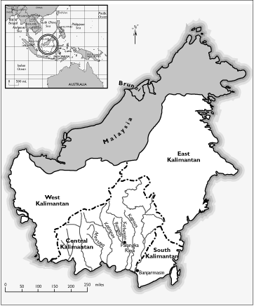
“Central Kalimantan,” for Anne Schiller, in Robert Winzler, ed., Indigenous Peoples and the State: Politics, Land, and Ethnicity in the Malayan Peninsula and Borneo, Yale Southeast Asia Studies Monograph #46 (1997).
All elements are in place and are approved by the author and editors at this stage. Text and explicatory graphics may appear outsized here because MetaGlyfix customarily produces maps for proofing larger than they are to appear in their published form. This allows authors and editors to see critical details clearly.
The map as laid out in the book, viewed at 50% scale
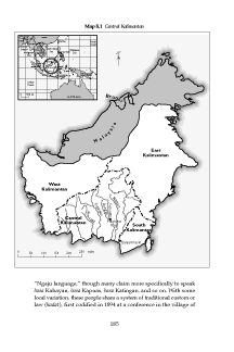
“Central Kalimantan,” for Anne Schiller, in Robert Winzler, ed., Indigenous Peoples and the State: Politics, Land, and Ethnicity in the Malayan Peninsula and Borneo, Yale Southeast Asia Studies Monograph #46 (1997).
(A page from the published volume, 50% scale.)
The map as laid out in the book, viewed at full scale

“Central Kalimantan,” for Anne Schiller, in Robert Winzler, ed., Indigenous Peoples and the State: Politics, Land, and Ethnicity in the Malayan Peninsula and Borneo, Yale Southeast Asia Studies Monograph #46 (1997).
(A page from the published volume, 100% scale.)
Last updated 14 August 2021 (Saturday) at 20:29:29 UTC ▲